Authored by Charles Hogger and Elizabeth Yin.
Overview
The Atlantic and central Pacific hurricane seasons run from June 1 through November 30, with the eastern Pacific season running May 15 through November 30; however, storms can form outside the official seasonal windows. The Atlantic hurricane season has a relatively defined peak August-October, with the eastern and central Pacific basins having a less defined peak July-September. The storm systems that form vary greatly in intensity and track and have the potential to impact a wide-ranging area of Central and North America. Storms in the eastern Pacific can generally impact anywhere from the Pacific coasts of Central America northwards along the west coast of Mexico and reaching the southwest coast of the US.
Atlantic storms’ range of impact extends from northwestern South America through Central America, eastern Mexico, the Caribbean, and the southeastern US northwards along the east coast to the Atlantic Maritimes in Canada. Outlying islands in both the Pacific and Atlantic, such as Hawaii and the Azores, can be impacted by storms; however, direct landfall is rare. Storm systems generally weaken upon landfall, making coastal areas the most at-risk. However, some systems can continue to track inland with varying intensities and bring adverse conditions to places far from the coast.
Hurricanes and other storm systems have the potential to have a major impact on areas they pass over, posing a threat to life and causing hundreds of billions of dollars of damage each year. The primary hazard from tropical systems is flooding caused by both storm surge (an abnormal rise in coastal or riverine waters caused by storm winds) and periods of heavy rainfall associated with the storms. Strong winds can also cause property damage, whip up dangerous flying debris as the storm passes, and generate rough seas that pose a threat to mariners and coastal residents. Tornadoes can also occur when storms make landfall.
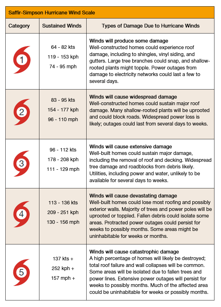
Hurricanes are usually measured using the Saffir-Simpson Hurricane Wind Scale (see Image 1), which categorizes hurricanes from 1 to 5 based on wind speed. Major hurricanes are generally classed as being category 3 or above. Whilst the scale can be used to gauge the expected level of wind damage the hurricane may cause, it does not take into account other environmental hazards such as storm surge, rainfall, and tornadoes. The intensity of a storm is not the only factor in determining the likely extent of its impact, with other factors also having a major influence.
For example, a slow-moving storm, regardless of its intensity, has the potential to produce lingering showers over a particular region, which may be more impactful than a higher intensity storm that passes rapidly through an area. Additionally, the relative vulnerability and preparedness of the location struck by the storm can have a great bearing on the level of damage and disruptions caused. For instance, due to limited resources and constraints in assistance reaching the population in need, some isolated islands in the Caribbean may be more heavily impacted by relatively minor storms than coastal areas of the US. If an island only has one airport or port and these are damaged during the storm it restricts their ability to receive aid.
Image 1 - Saffir-Simpson Hurricane Wind Scale
2022 Outlook
Forecasters take into account a combination of climatic indicators, including sea surface temperatures and the El Niño-Southern Oscillation (ENSO) weather pattern, and compare these to previous historical trends to formulate a probabilistic assessment of the likely level of tropical cyclone activity for the upcoming season. Warmer sea surface temperatures provide conditions more favorable for tropical systems to form. La Niña weather patterns tend to favor stronger activity in the Atlantic basin and suppress activity in the Pacific basins.
Conversely, an El Niño pattern suppresses activity in the Atlantic basin and enhances it in the Pacific basins. Forecasters are unable to provide early accurate predictions of precisely where hurricanes and other storms systems are likely to make landfall each season as the track of each particular storm system is determined by the specific weather conditions present during the formation and passage of the storms; however, some estimates can be gauged on the number of storms expected in a relatively wide geographical area based on the predicted level of activity during the season and the comparison to historical seasons, as well as taking other environmental factors into account.
A Quick Look at the Forecast
The National Oceanic and Atmospheric Administration (NOAA) has predicted the following hurricane activity levels across the Atlantic, eastern Pacific, and central Pacific basins for 2022:
Atlantic: Above-Normal Season Likely
Eastern Pacific: Below-Normal Season Likely
Central Pacific: Below-Normal Season Likely
Atlantic Basin
NOAA’s outlook for the 2022 Atlantic hurricane season indicates an above-average season is most likely. The outlook has forecast a 65% chance of an above-normal season, a 25% chance of a near-normal season, and a 10% chance of a below-normal season. The basis for this outlook is due to warmer sea-surface temperatures in the Atlantic Hurricane Main Development Region (MDR) in the tropical North Atlantic and Caribbean Sea, expected weaker vertical wind shear, an enhanced West African Monsoon, and a likely La Niña weather pattern during the hurricane season. Models indicate a 58% likelihood of a La Niña event, as opposed to a 38% chance of an ENSO-neutral event and a 4% chance of an El Niño event.
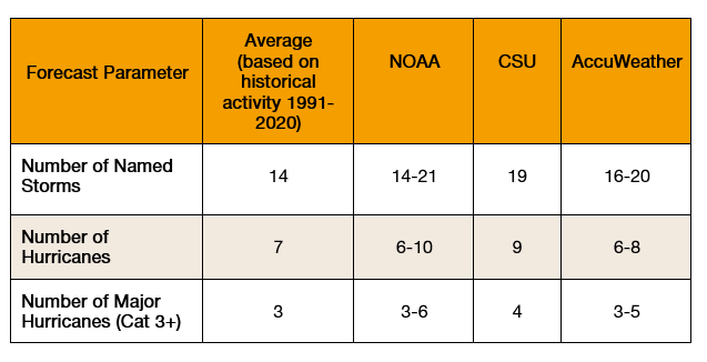
Along with NOAA, other respected forecasters are generally predicting a slightly higher number of named storms, hurricanes, and major hurricanes than during an average hurricane season (see Table 1). As with most Atlantic hurricane seasons, the majority of the activity is expected to occur during the peak months of August, September, and October.
Table 1 - 2022 Atlantic Hurricane Season Forecast
Colorado State University (CSU) have produced some probabilities of the likelihood of hurricanes making landfall over particular areas in their extended-range forecast for the 2022 Atlantic hurricane season. CSU has forecast a 71% probability of at least one major hurricane (Category 3 or above) making landfall across the entire continental US coastline (the average probability for the last century is 52%).
More specifically, they predict a 47% chance of at least one major hurricane making landfall on the US East Coast, including the Florida Peninsula, and a 46% chance on the Gulf Coast from the Florida Panhandle westward to Brownsville on the US-Mexico border in Texas (compared to historical averages of 31% and 30% respectively). CSU has also predicted a 60% probability of a major hurricane tracking into the Caribbean (average for the last century is 42%). AccuWeather has predicted 4-6 named storms will directly impact the US during the season, compared to a historical average of 3.5.
Eastern Pacific
NOAA’s outlook for the 2022 eastern Pacific hurricane season indicates a below-average season is most likely. Forecast models predict a 60% chance of a below-normal season, a 30% chance of a near-normal season, and a 10% chance of an above-normal season. Similar climatic reasoning behind the above-average forecast for the Atlantic basin has formed the basis for the below-average forecast in the eastern Pacific.
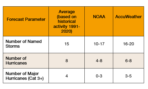
The La Niña weather pattern and above-normal temperatures in the Atlantic MDR favor reduced hurricane activity in the eastern Pacific. Below- or near-average sea surface temperatures are expected across the eastern Pacific, which also favors a near- or below-average season. A considerable number of storms are still likely to form (see Table 2), with activity likely to peak July -September. AccuWeather has predicted a slightly higher level of activity than NOAA and has forecast that 2-4 storms will make direct impact on the Mexican coast, compared to a historical average of 2-3.
Table 2 – Eastern Pacific Hurricane Season Forecast
Central Pacific
After a quiet year in 2021, when there were no named storms in the central Pacific, another relatively sedate season is expected in 2022 due largely to the same climatic conditions that have led to the below-normal forecast for the eastern Pacific basin. NOAA’s outlook for the 2022 central Pacific Hurricane Season predicts a below-average season is most likely. There is a 60% chance of a below-normal season, a 30 % chance for near-normal activity, and a 10% chance of an above-normal season.
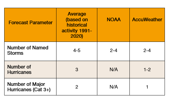
Only a handful of tropical storms occur on average each year in the central Pacific, so it would only take one or two unexpected storms to form or to strengthen significantly to push the season from being below-normal to near- or above-normal. However, the risk of any direct impact on Hawaii remains low.
Table 3 – Central Pacific Hurricane Season Forecast
These forecasts are based on the best available data, a high level of scientific analysis, and extensive use of historical patterns to make the most accurate possible predictions for the season. However, there is always a degree of uncertainty with any forecast and any significant change in climatic conditions could alter the level of activity in each basin.
For example, there is uncertainty as to whether La Niña conditions will prevail throughout the season or whether sea surface temperatures will continue to follow their current trend. Even if conditions do stay as predicted, it is very rare that La Niña conditions have dominated for three consecutive seasons, which means there is less reliable historical data on which to base forecasts.
And regardless of activity levels, the real impact of the hurricane seasons will be determined by the tracks they form and where they hit. It only takes one storm to create a disaster. Therefore, anyone living or traveling within the region over the next few months should make sure they keep up to date with local weather reports and take steps to ensure they are prepared for the eventuality of being impacted by tropical systems.
Impact of Hurricanes
The most visible impacts of hurricanes are often seen in the path of destruction they leave in their wake. Flooding, strong winds, and rough seas brought by the storm systems can cause fatalities and injuries as well as damage or destroy homes, businesses, and agricultural land. These impacts can affect livelihoods and cause large economic losses.
Damage to infrastructure can cause widespread power outages, contaminated water supplies, and interruptions to internet services and mobile communications. The passage of a hurricane can put great strain on health and emergency services, which at times can become overstretched by the multitude of demands for their services.
Hurricanes can also result in major supply chain disruptions and economic impacts even if only one strong system comes onshore. Flooding, storm surge, and destructive winds not only threaten the personal safety of those operating in the path of a storm but also have the potential to destroy infrastructure, complicate supply chain operations, and contribute to major transport disruptions. Transport closures and panic buying ahead of an approaching storm system can lead to a lack of available goods and services in the immediate aftermath of a storm.
The road to recovery following the impacts of a hurricane can be a long and expensive one. It can take months or years for areas to be restored to something resembling their previous state, and there is no guarantee that another storm system will not strike the same area as the recovery is ongoing.
Damage to airports, ports, rail lines, roads, and other transport infrastructure can lead to difficulties in receiving aid or other goods required in the aftermath of a hurricane. There are many other secondary long-term impacts which can be attributed to a hurricane, such as a drop in tourism, poor agricultural conditions for future crops, and even long-term mental and physical health impacts on the local community.
Preparation Measures
Regardless of the forecast levels of hurricane activity, anyone living, operating, traveling, or with business interests in areas that have the potential to be exposed to tropical systems are strongly advised to take measures to prepare for the upcoming hurricane season. Below are some simple tips on ensuring preparedness to be in a better position for the eventuality of being affected by hurricanes:
- Assess your risk: Conduct a thorough hazard and vulnerability assessment to better understand your potential exposure to storm systems. Consider possible worst-case scenarios and the potential direct and indirect impacts these could have on your business, home, or premises. Try to gain a good understanding of what hazards are likely to have the largest impact and take any practical steps available to mitigate the level of risk.
- Review insurance policies: Ensure any business, home, or travel insurance policies cover any damage, cancellations, or loss of income that may be incurred following a hurricane. While some schemes may cover wind damage sustained during hurricane activity, supplementary protection policies could be required for derived events like flooding, landslides, or storm surges.
- Stay informed: Monitor local weather agencies and local media for updates on storm systems. As a storm system approaches, agencies generally provide regular updates on the forecast track and intensity of the storm, so be sure to check regularly to ascertain the likely level of impact on your particular area of operations. Sign-up to travel security alerts, emergency management agency alerts, and any other available community alerts to ensure you are informed of any weather or local authority advisories regarding approaching storm systems.
- Have a plan in place: Create, review, or update any existing contingency, business continuity, or home emergency plans to ensure they are relevant and proportionate to the potential threat posed by hurricanes. Check that all emergency contact numbers are up to date and, where possible, identify evacuation routes in case the need arises.
- Have supplies ready to go: Gather an emergency kit or go-bag in case of the need to either shelter in place or evacuate. Essential items include (but are not limited to) water, non-perishable food, torches, first-aid kit, batteries, radio, medicines, sanitary products, cash, ID, and paper copies of any important documents, as internet access may not be possible in the aftermath of a storm. Be sure to regularly check that items in your kit are working and in date.
Staying Safe During and After a Hurricane
Meteorological agencies are often able to monitor the formation of hurricanes and other storm systems and gain a good understanding of their likely track and intensity as they develop. Therefore, some notice is usually given to potentially affected communities before a hurricane strikes. If there is enough notice and the option is available to self-evacuate before the arrival of a storm system, then it is advisable to do so at the earliest opportunity.
Authorities can close airports and ports as the storm closes in, meaning the opportunity to leave may disappear at short notice. Various factors can mean it is not always possible to vacate the path of the storm, such as family or business commitments to an area or a late change in track or increase in intensity of a storm system. If you do find yourself in the position of having to ride out the storm, follow the below advice:
- Final preparations: If there is time to do so, take measures to strengthen your home or premises against the possible impacts of the storm. Board up windows, secure any loose structures or items, and clear gutters to enable water to flow through them. Make sure electronic devices are fully charged in preparation for possible power outages. Take the opportunity to familiarize yourself with emergency or evacuation plans in case they need to be activated.
- Follow the advice of authorities: Continue to stay up to date with weather and media updates for information regarding the storm and any local authority advisories. Heed any evacuation orders issued and do not return until authorities have deemed it safe to do so.
- Hide from the wind, run from the water: As the storm passes, you should shelter in a designated shelter or interior room of your home away from any windows. Only leave if flooding occurs in your location, in which case move as safely as possible to higher ground. Do not attempt to drive or walk through floodwaters – turn around, don’t drown. Only call the emergency services if you are in life-threatening danger, as they are likely to be extremely stretched during this period.
- Post-hurricane: Beware of continuing hazards after a hurricane has passed. Only leave your place of shelter once authorities have confirmed it is safe to do so. A brief lull in the wind could be mistaken for the storm being over when in fact it is the eye of the storm passing through, and intense winds could soon return. Be careful and wear protective clothing during clean-up. Do not touch any electrical equipment if it has come into contact with water or if you are in standing water. Damp conditions can also provide a breeding ground for mold and water-borne diseases. Save phone calls for emergencies only. Phone systems could be down or overwhelmed so use SMS or social media to inform people you are safe and to check the safety of others.
Crisis24 provides in-depth intelligence, planning, and training, as well as swift and actionable responses to keep your organization ahead of emerging risks. Contact us to learn more.
Author(s)

Charles Hogger
Intelligence Analyst II, Weather and Environment Team
Charles joined Drum Cussac (prior to its integration into Crisis24) as a Global Operations Officer in April 2018, gaining an in-depth knowledge of the many operational aspects of the business, before...
Learn More
