More than half of the land area of the US is covered by forests, shrublands, and grasslands. Wildfires occur naturally and play an important role in the health of these ecosystems. However, over the past two decades, warmer springs and longer dry summers have resulted in drier soil and vegetation, increasing the length and severity of the wildfire season.
Wildfires start from a combination of dry fuel, such as leaf litter or other organic debris, and an ignition source (generally lightning strikes or human activity). The speed at which the fires spread and the intensity at which they burn depends on wind speed, ambient temperatures, slope angle, the amount of fuel available, and the amount of moisture in the fuel.
In general, more wildfires occur in the East and Central states but wildfires in the West burn more acreage. While the wildlife season commonly runs from May to October, wildfires can start at any time of the year. Forecast models indicate an above-normal wildfire season due to below-average precipitation over the past few months, especially over the Northwest and West. The 2022 North American Monsoon with above-average precipitation is forecast to start from July over the Southwest, decreasing the wildfire threat. However, early storms in June over the Southwest and southern Great Basin, as well as Colorado, could ignite new fires due to lightning strikes.
May-August 2022 Outlook
Figure 1 US Drought Monitor forecast areas under drought conditions.
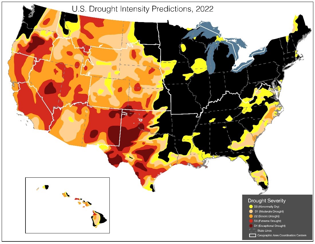
- Much of the West, Plains, and Texas as well as along the Gulf Coast and South Florida remain in drought. In April, temperatures were above normal across the Southwest and Texas while below-normal temperatures were recorded across much of the northern US.
- Below-normal precipitation persisted in April in the Southwest and the central and southern Plains. The snowpack continues to rapidly melt in the Southwest while the below-normal snowpack in the Northwest and Rockies is melting off at a slow rate.
- Forecast models indicate below-normal precipitation across much of the Plains westwards through the central Rockies to the Northwest and above-normal temperatures across much of the contiguous US from spring into summer. Windy and dry conditions are likely to continue across the Southwest and central and southern High Plains through June.
Figure 2 A-D National Interagency Fire Center (NIFC) forecast areas anticipated to have higher than average significant wildfire potentials May-August
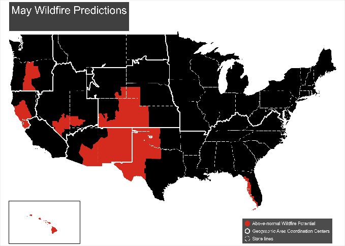
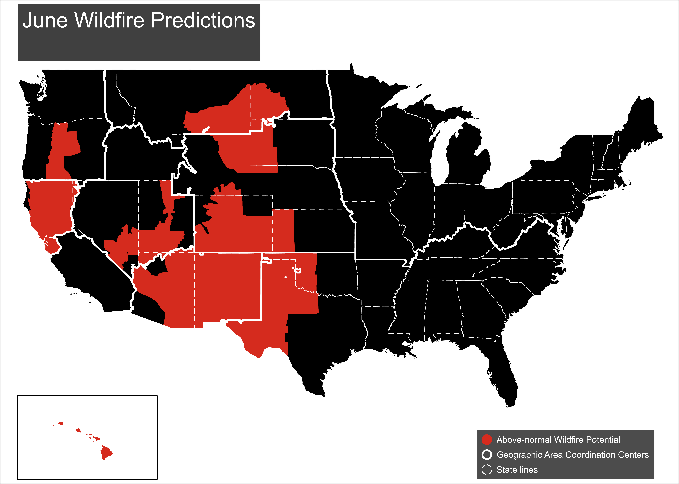
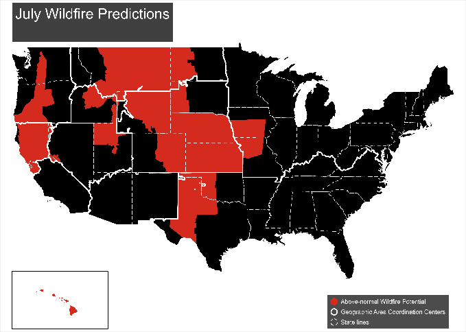
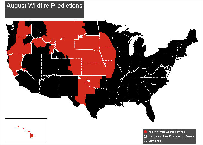
- Above-normal significant fire potential is forecast across the western Florida peninsula in May, most of the Southwest (May-June), northern California (May-July), the leeward side of Hawaii's islands (June-August), and the southern High Plains (May-August). The rest of the Plains are forecast to have above-average fire potentials from July before spreading to the western Mid-Mississippi Valley in August. Above-normal fire potentials are forecast to expand from central Oregon to southwest Oregon and central Washington by July and most of the Northwest in August.
In April, most of the Southwest, Great Basin, and southern and central High Plains received below-normal precipitation with the driest areas across portions of the Desert Southwest, west Texas, eastern Colorado, Kansas, and Nebraska. La Nina conditions are ongoing, resulting in below-average sea surface temperatures across most of the equatorial Pacific Ocean. Temperatures are forecast to be above normal for much of the US June through August while precipitation is likely to be below average across the Pacific Northwest, especially east of the Cascades over the same period. Fire activity over the Southwest increased significantly in April. Increases in fire activity were also recorded in California, the Great Basin, Eastern Area, and across the plains of the Rocky Mountain Area due to dry and windy conditions.
Several Pacific cold fronts in April resulted in above-average rainfall and below-average temperatures across much of the Northwest region including the Columbia Basin. However, portions of central Oregon and the Okanagan region of eastern Washington remained dry. Forecast models indicate an elevated risk for significant fires in central Oregon through June due to dry and windy weather. The elevated risk is forecast to expand into southwestern Oregon and central Washington in July and the rest of the Northwest in August.
Above-average fire potential is forecast across the Bay Area, Mid Coast-Mendocino, and Sacramento Valley-Foothill in May before expanding across most of Northern California from June through August due to above normal temperatures and slightly below normal precipitation. Drought conditions over Northern California are likely to intensify over the coming months. Below-normal to normal fire potentials are forecast for southern California through August due to well below-normal fine fuel loads as well as above-normal monsoonal activity July through August.
Above-average temperatures due to higher-than-normal sea surface temperatures are forecast throughout Hawaii through July. Precipitation is forecast near to slightly above normal through May, especially over the windward side of the islands from La Nina enhanced trade winds. As the dry season starts, precipitation is forecast to be drier than normal from June-August. Above-average fire potential is forecast across the leeward side of the islands through August due to dry fuels, intensifying drought, and periods of enhanced trade winds.
Areas east of the Rockies are likely to have above-normal fire potential from July-August due to the ongoing drought with the potential to worsen over the summer months. Fuel moisture is below average although extensive snow cover has reduced the wildfire threat in April. Additional rainfall through at least May and possibly into June is likely to reduce the wildfire threat. Forecast models for the areas west of the Rockies are more uncertain. Precipitation over the summer may be sufficient for normal fire potentials. Most areas east of the Divide, except for North Dakota remain in drought. Northern Idaho and northwest Montana are no longer under drought conditions although some areas are still abnormally dry.
Drought conditions have improved but still persist across the Great Basin. Forecast models indicate significant wildfire potential will remain low through early May and increase from mid-May through June from south to north. If the snow melts early where drought is still prevalent, especially at higher elevations in Utah, above-normal fire potentials are likely. Southern and eastern Nevada are likely to develop above-normal fire potentials by May and June and over the higher terrain of northern Utah, the Sierra and parts of Idaho and Wyoming due to the presence of grasses. Drier conditions over the past few months have reduced grass growth, limiting fire potentials at lower elevations.
Above-normal fire potential is forecast for most of the Southwest except for the western regions in May before expanding farther north and west in June. The arrival of the North American Monsoon is likely to lower fire potentials back to normal in July. Drier than normal conditions have been recorded over the Southwest, except for central New Mexico and the Four Corners region, over the past few weeks. Despite the potential for storm systems to impact the Southwest from the west and northwest, overall, temperatures are forecast to remain above normal with drier than normal conditions.
The Rocky Mountain region is likely to have above-normal fire potentials through August as above-normal temperatures and below-normal precipitation are forecast to persist and expand throughout the period. Forecast models indicate an increase in lightning ignitions in late June preceding the timely onset of the North American Monsoon.
Due to the continuation of extreme drought conditions and a high-pressure area over the Intermountain West and Plains bringing above-normal temperatures and below-normal rainfall, above average fire potentials are forecast to persist in most of western Texas and Oklahoma through at least August. The North American Monsoon is forecast to start by July, bringing rainfall to the Texas mountains, and reducing the wildfire threat.
The western Florida peninsula is forecast to have an above-normal risk for large fires through May due to large areas of drought conditions and high evaporative rates over the past month. Warmer than normal sea-surface temperatures and the onset of the rainy season are likely to result in thunderstorms by June, reducing the wildfire risk.
Impact of Wildfires
Wildfires can result in loss of life or impact public health, cause environmental, property and infrastructure damage, as well as effect economic losses. Besides increasing air pollution, smoke from wildfires can hurt the eyes, irritate the respiratory system, and worsen chronic heart and lung diseases. Smoke may also worsen symptoms for people with pre-existing respiratory or heart conditions. People and wildlife may also suffer burns and trauma.
Increased soil erosion is likely across burn scars during bouts of rainfall due to loosened soil and loss of vegetation. Power outages are possible in places due to damaged substations and transmission lines. Intentional power cuts may also be necessary to prevent infrastructure damage or help in preventing the spread of fires.
Supply chain disruptions can occur, especially if wildfires burn across highways and roads or approach large population centers. Wildfires can also lead to evacuations, road closures and ground transport diversions. Disruptions to arterial roads and the scarcity of alternative routes in some areas means that significant transport disruptions will increase. Roads in remote regions are likely also to be disrupted for longer periods than urban roads due to their relative inaccessibility.
Low visibility from smoke and possible ashfall could contribute to traffic delays and congestion and prompt short-notice flight disruptions if wildfires occur near airports. Railways can also experience occasional cancellation of services and long delays.
Many warehouses, factories, and other supply chain related businesses tend to be located in the suburbs with a higher likelihood of being affected by wildfires as compared to city centers. Wildfires can destroy crops and livestock, resulting in economic losses. Businesses are also likely to be adversely affected by the supply chain disruptions especially if they require transportation of perishable goods.
Crisis24 provides in-depth intelligence, planning, and training, as well as swift and actionable responses to keep your organization ahead of emerging risks. Contact us to learn more.
Author(s)
Elizabeth Yin
Intelligence Analyst I
Elizabeth Yin joined the Crisis24 Weather and Environment Team as an Intelligence Analyst in 2021 and holds a Bachelor’s degree in Marine Geoscience, Geology, and Geophysics from the University of...
Learn More


